

Table of Contents
The city of Dehradun is so famous for its fantastic views that are both sides of the city being surrounded by the Shivalik Range, which lies on the southern side, and hills further south of the Himalayas, that it has become the capital of Uttarakhand, nestling. The unique geography of Dehradun has had a very elaborate impact on the region’s climate, culture, and development, which, in turn, has become one of the most beautiful and strategically significant cities in northern India.
The Geography of Dehradun: Location and Boundaries
Dehradun is a beautiful city in the state of Uttarakhand, which is settled in the Doon Valley. The valley is situated between two holy rivers – Ganga and Yamuna. The Ganges River flows on its eastern bank, while the Yamuna River flows on its western bank. Thus, the geographical location of Dehradun makes it special.
The city is located at an elevation of about 450 to 700 metres (about 1,400 to 2,300 ft) above sea level. Due to this reason the weather here remains pleasant and moderate throughout the year. Even when the temperature in the plains rises very high in summer, Dehradun remains mildly cool. It’s a bit chilly in the winter, but most of the time it’s a pleasant stay.
Dehradun borders Mussoorie in the north. Mussoorie is a famous hill station, which is called the “Queen of Hills.” Every year a large number of tourists from home and abroad come here. The journey from Dehradun to Mussoorie is only a few hours, which makes it more attractive.
In the north-west direction, Dehradun is connected with Himachal Pradesh. This part of Himachal is full of natural beauty and attracts tourists towards itself.

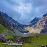
Geography of Dehradun: Topography
The topography of Dehradun is defined by its beautiful valleys, rivers and rolling hills. This city is mainly settled in the plain area, but as you move towards the north, its height gradually increases and from here the high and low hills of the Himalayas begin. At the same time, the lower Shivalik hills of the white belt stretch to the south, giving the region a natural slope.
The river Yamuna flows to the west of Dehradun and the river Ganga flows to the east. These two rivers not only enhance the natural beauty of the region but also make the soil here fertile.
Due to these rivers the terrain of Dehradun remains green and the farms here are seen swaying with the crops. Nestled between the Yamuna and the Ganges, this region is also known for its favorable climate and fertile soil, where the kingdom of greenery always prevails.
Being situated between the Shivalik Hills and the Himalayas, the topographic landscape of Dehradun is extremely fascinating and diverse. The natural valleys, forests, and rivers that surround the city make it a peaceful and idyllic place. This area is not only a paradise for tourists, but nature also has a special place in the lives of its inhabitants.
This unique mix of topography of Dehradun makes it different from other cities. The slope of the land here, the expanse of the hills and the presence of rivers, make this city naturally rich and beautiful. This is the reason why Dehradun is considered an important place in North India.

Geography of Dehradun: Climate
The climate of Dehradun is tropical humid (Cwa). The city is located in the Doon Valley, where there is considerable variation in temperature due to the difference in altitude. In the hilly regions the summer season is pleasant, while in the plains of the Doon valley the heat sometimes becomes very intense. Temperatures can reach 40 ° C (104 ° F) on hot summer days. Like other parts of North India, hot winds blow here in summer.
Winters are cold here. Temperatures usually range between 6 ° C to 20 ° C (43 to 68 ° F). Although the temperature sometimes falls below zero on cold days, it is very rare to see this.
The region receives an average of 2, 073.3 millimeters (81.63 in) of precipitation each year. Most of the rainy months of the year fall between June and September. July and August are the rainiest months. During monsoons, there is often heavy and continuous rain here, which floods the rivers and drains and cools the atmosphere.
The climate and natural conditions of Dehradun are quite favourable for agriculture. The soil here is fertile alluvial soil, which is considered better for crops. Also, adequate rainfall and good drainage system help in cultivation.
For this reason, rice, wheat, maize and other crops are grown in good quantities here. This climate of Dehradun is also considered very attractive for tourists, who come to enjoy the beauty of here in the summer and winter season.

Geography of Dehradun: Rivers and Water Bodies
Dehradun (Doon) valley is a place of unique beauty, where numerous rivers, rivulets and seasonal water sources flow. Major rivers of this region are the Ganges and the Yamuna, which are considered to be among the most sacred rivers of the country. Apart from these, other important rivers like Tons and Asan also flow here. These rivers and water sources make the natural beauty of Dehradun even more attractive.
It runs between the hilly areas of this valley and the forests before flowing into the Tons River, which is actually one of the largest rivers in the Doon Valley, and is not only its main source of water, but also plays an essential part in maintaining the ecological balance. Along with the Asan River too, it is a treasure of natural heritage.
Asan Barrage has emerged as a beautiful spot on its course, where a large number of birds and other wild creatures can be seen. Flora and fauna are found on the banks of these water sources. It makes the region a home of biodiversity.
The surroundings of the water sources- lush green forests and hills- present a soothing image. Seasonal rivers and streams here flow full speed during the rainy season and give life to the valley.
Water sources in Dehradun are symbols of aesthetic beauty and at the same time highly significant for local livelihoods and agriculture. These rivers contribute to water being irrigated across the fields that makes these crops thrive.
Rivers were part of local culture for centuries and thus an inherent part of lifestyles here.

The Influence of Geography on Development
Over the years, the growth of Dehradun has been greatly affected by its geographical conditions. Its favorable position as a doorway to the Himalaya range made this city quite a city during the British Raj in its efforts to counter military aggression as well as scientific expeditions.
Nowadays, many national institutes with various functions have been established, the Indian Military Academy being a notable one along with the Forest Research Institute and Survey of India among others.This region is located on important routes connected to major cities of North India, which proves to be beneficial for trade and industry.The geography of Dehradun not only reflects its historical importance but also decides the course of its present and future development.
Frequently Asked Questions on Geography of Dehradun
1. Where is Dehradun located geographically?
Dehradun is a city in the Doon Valley, in the state of Uttarakhand, India. Between the southern edge of the Shivalik Hills and its northern side, the lower Himalayas run. The eastern part touches the Ganges River, and the Yamuna River lies west of this city.
2. What are the unusual geographical characteristics of Dehradun?
The peculiar geography of Dehradun lies between two major rivers, alluvial fertile soil, and a natural slope from the Shivalik range to the Himalayas forming diverse topography of plains, hills, and valleys.
3. How is the climate in Dehradun influenced by its geography?
Dehradun is at a height of 450-700 meters above sea level, and hence the climate is temperate. Summer is not as hot as in the plains and winter is cool, although sometimes it becomes too cold. Monsoons are accompanied by good rains.
4. Role of rivers in Dehradun’s ecosystem?
The rivers, for example, Ganges, Yamuna, Tons, and Asan are necessary for agriculture, biodiversity, and ecological balance in Dehradun. They help to irrigate, maintain forests and wildlife, and make the landscape beautiful.
5. Why is Dehradun important for development?
Its strategic position has made Dehradun an important education, research, and military training center since it was a gateway to the Himalayas and fertile land. The Indian Military Academy and Forest Research Institute speak for themselves about this significance.
6. How does Dehradun geography affect its tourism?
Its lovely valleys, proximity to Mussoorie, rivers, and gentle climate attract visitors throughout the year. The place offers trekking, sightseeing, and bird watching. Asan Barrage is one of the favorite spots for bird lovers. 7. What is the topography of Dehradun like?
Geography wise, Dehradun offers some part with flat plains in the southern zone and hilly slopes in northern sides, with fertile lands well-endowed by rivers Ganges and Yamuna. Shivalik hills give a natural slope to the region.
8. What crops are commonly grown in Dehradun?
The fertile alluvial soil and adequate rains favor crops like rice, wheat, maize, and sugarcane. The valley is also known for their basmati rice.
9. How does geography play a crucial role in the cultural significance of Dehradun?
This region has its geographical condition that started influencing cultural aspects for decades. Local ways of living, activities, and cultural rites combined with agricultural procedures followed ancient patterns that did not shift much from regional geographical connotations.
10. Which are the issues associated with Dehradun geography?
Rivers are overused and polluted, and it affects the entire management of water. Fast urbanization and deforestation have an effect on the ecological balance of this area. Monsoon-season floods also hit the valley.
Final Thought
The geography of Dehradun is a balanced mix of natural grandeur, strategic importance, and cultural wealth. This falls between the Shivalik Hills and the Himalayas. This city represents fertile plains, lush valleys, and pure rivers all combined together in a singular entity. Geography has, to a considerable extent, shaped the climate, development, cultural heritage, and ecological significance of this city. When Dehradun grows, retaining its natural landscape and using its resources without wastage would prove to be a prime determinant to ensure this gateway to the Himalayas continues to remain an awe-inspiring gateway.

[…] gardens, orchards, and a tranquil pace of life. But the scenario today is quite different. This Earth Day, let’s look back at what Dehradun was, understand what we’re losing, and discuss how we can […]